
The first two days of my week were office days. I spent most of time working on the
With Memorial Day weekend, this was a very short week again. Tuesday was spent in the office working on some admin and paperwork.
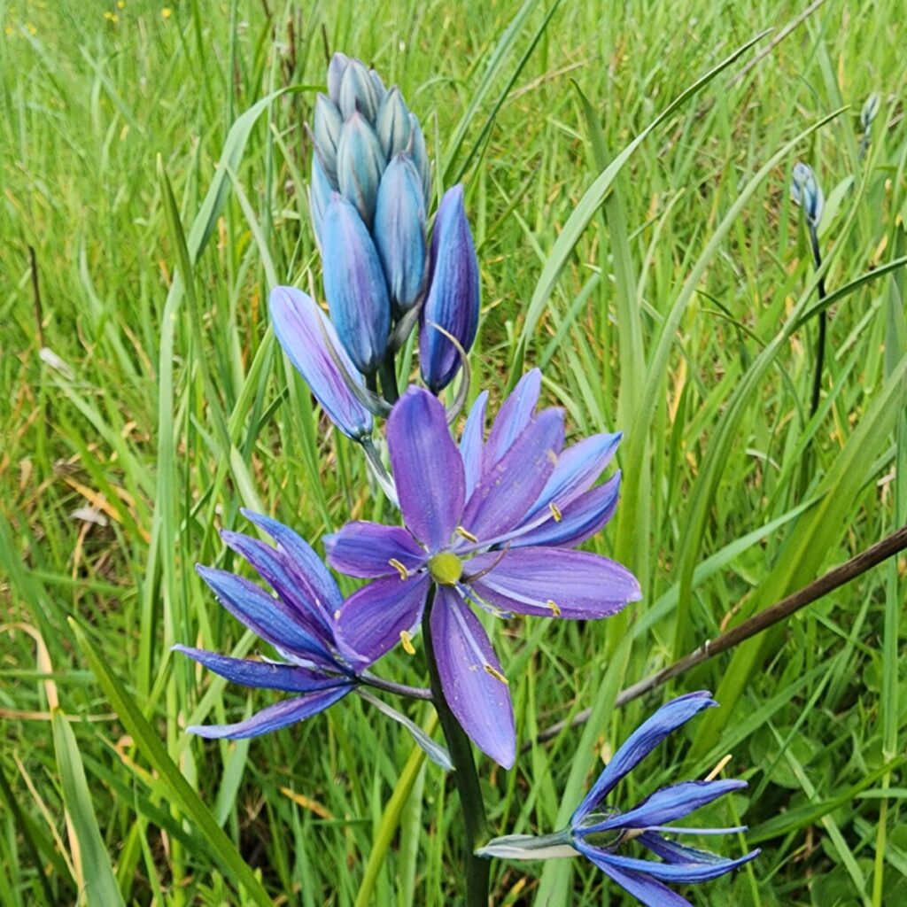
Wednesday we went out to monitor at a Lewis County WCCRI site. We came out monitor vegetation as well as facilitate a small burn for the landowner. We got the burn permit and CNLM came out to start and monitor the burn while we monitored vegetation. This burn was mostly to get rid of old debris from the previous landowner. The current owners have only been here for about 2 years and are working slowly to restore this beautiful old farm. This means lots of clean-up from land that was neglected for decades. Both of the owners are former wildlife biologists who decided they didn’t like city life, so they moved out to this property and want to homestead and steward the land. The wife is currently a professor in Seattle and the husband works for the Department of Ecology, so they are both very educated and very dedicated to conservation. He stayed home today and helped all day with the burn. The plan is to hopefully get the rancher Ecostudies uses to bring his cattle out later in the season after the fences are fully finished and a few other repairs are made. This is our second year monitoring here and it has surprisingly great pasture. There aren’t a ton of invasives on the site and most that is there should be pretty well controlled by the cattle. The best part is that he has a patch of Lupinus oreganus ( Kincaids Lupine), which is Endangered in Washington State and Threatened federally (https://www.dnr.wa.gov/publications/amp_nh_luor.pdf). This is the northern most population of the species and it has apparently grown since they found it last year!


After we finished out plots it was time to help with the fire! We got most of the debris and wood burnt down throughout the day and we didn’t catch anything on fire that wasn’t supposed to be. We started it with one drip torch and some scrap cardboard pretty easily. It was all pretty wet and we had rain throughout the day, but we kept the fire fed and happy. We had a leaf blower for adding air when needed, two water bags with handpumps, and some rake/pulaskis/flappers to keep it off the grass if the wind shifted. Thankfully the weather cooperated with us. The went was blowing down the valley all day like we wanted and the relative humidity and precipitation played nice with us as well.


Thursday was spent working with CNLM at their Native Plant Nursery. Ecostudies and CNLM work very closely so we go out and volunteer pretty frequently when they need some help. Their seed farm provides most of the seed that both organizations use for habitat restoration. We just weeded part of the Lupinus albicaulus beds all day. We also got a little tour before we left. They also grow Seabluff, Balsamroot, Columbine, Collinsia, and a few other species that i didn’t get a chance to see. They have three farms as well that they split their time between. I’m hoping to get some more chances to work with them throughout the year and get some experience with another organization that i enjoy working with!


With only one week left in this quarter I’ve been reflecting alot on the chaotic, but educational quarter I’ve had. I’m very excited to see where else this internship takes me in the next three quarters and I’m so fortunate to have this opportunity.
This was a short week with due to some personal illness. The weather was just awful, so most of my time was spent in office. Monday and Tuesday I mainly worked on paperwork and some general admin work. We did get a break in the weather, so Arthur and I went out to visit a CREP site. This site is past the point where we maintain it, so at this point the landowner is responsible for maintaining the area by mowing and spraying invasives. Our main purpose was to go and verify that he had been out doing the work. He had, but it wasn’t very effective at all. It was another example of how difficult it is to maintain habitats without invasive species unless you really put in the work. It was difficult to see much good on the site, it was mostly invasive species that had been sprayed, but not effectively. The landowner had also done his own culvert “repair”, which he is allowed to do, but we could have offered some technical assistance and guidance.


Wednesday the weather was nice enough to let us go out and doing some vegetation monitoring with Ecostudies. We went to the Veterans Ecological Trade Collective( VETC), which is a crazy place. It is a former rabbit farm/composting facility that was bough to help veterans learn agriculture and trade experience. It doesn’t seem like it was very successful, and recently just closed with no explanation. It sounds like VETC is going to gift the land to the Chehalis Tribe though, but not all of the details are figured out yet. Apparently this facility was attempting to help people dispose of toxic waste at some point, because there is a giant pile of asbestos and a pond of arsenic on the property, so the Tribe has tons of work ahead of them.


We finished the monitoring pretty easily. The site doesn’t really have much good going on. We found essentially all non-native species as well as some bear scat in our plots. It was a cool place to explore though during our breaks, but a place where you should tread carefully.
Thursday i came down with some illness and was out all weekend basically. I ended up losing 9 pounds and couldn’t get out of bed, so it wasn’t the best weekend I’ve ever had.
Monday was another office day working on my farm plan as well as just some general office and admin work. I’m still slogging along and working on my pesticide applicator’s license, but I haven’t fully committed to it yet. All of my prescribed burn training is completed with the exception of the practical portion, which will be done in mid-June. I completed the physical portion as well, which is a 1.5-mile run in 11:40 or a 3-mile ruck with 45 pounds within 45 minutes. I chose the run and sent it in, so I’m very ready to start burning! I’ve been spending some time reviewing field guides for plant ID skills, mostly for grasses.
The rest of the week was spent with Ecostudies Institute shared resources crew. My manager spent the week down in Hamilton, Washington spraying invasive weeds with an Americorps Intern. That work is funded by a different grant, so I couldn’t go down to help. Instead, I helped with vegetation monitoring on a few other sites. The shared resource crew works on projects that don’t fall directly under Ecostudies but are managed for prairie restoration by other entities that may not have the crew-power that we have. The main organization we work with is the Center for Natural Lands Management (CNLM) which is a non-profit that stewards and protects vitals lands in California, Oregon, and Washington. Typically, they own the lands they manage but also hold conservation easements on many preserves and properties and manage those as well. We also will do work on DNR and WDFW lands as well such as West Rocky Prairie. The first site we monitored was Wolf Haven. Wolf Haven is a sanctuary for wolves and wolfdogs that typically come from private ownership and aren’t able to be released back into the wild. The sanctuary does a ton of educational work as well as conservation work for their habitats. They also own and steward 36 acres of prairie habitat with some great butterfly habitat as well as plenty of mounds. Sadly, I didn’t get to see any wolves since we were monitoring and it is breeding/whelping season, so visitors aren’t allowed at this time. We only had one plot left here to finish so Trent (the shared resources crew lead), Noel (an Americorps intern) and I knocked out that plot before met up with the rest of our crew at Cavness Ranch.

Shared resources use a different method of monitoring than our WCCRI crew, so it took a little time to get used to. They set up one 25-meter line running south the north with cross sections at 6.5-meters, 12.5-meters, and 20 meters. The 6.5 and 20-meter lines are 12.5-meters long while the 12.5-meter line is 25-meters in length. Their measurements on each line are slightly different than ours as well. They do point-intercept and area searches like we do as well, but don’t worry about cover or bird habitat. They do focus more on butterfly habitat though. They measure habitat for several different butterfly species (primarily the Taylor Checkerspot) by looking at numbers of Plantago lanceolata and Castelleja hispida. We also look at numbers of Lupinus species, Microsteris species, Lomatium species, Camassia quamash, and Plectritis congesta.

Didn’t expect to find bones while vegetation monitoring, but apparently some of the wolf snacks made it out here.
Following that we went out to join the rest of the crew at Cavness Ranch. The conservation easement was granted to the Nature Conservancy in 2005 and was then transferred to CNLM in 2019. It is 613 acres which CNLM holds the conservation easement for. It has a pretty varied past and was used for logging, cattle ranching, and then was a Christmas tree farm prior to CNLM. It has a pretty interesting spread of habitat as well. All of this information is straight from the CNLM website Center for Natural Lands Management | Cavness Ranch (cnlm.org). It currently has 50 acres dedicated to rare Oregon white oak habitat, 102 acres as current prairie habitat, and 56 acres that was a Christmas tree farm until last year. It has been mostly cleared now but hasn’t been seeded for prairie yet. It looks like they are still clearing dead trees and prepping the land for seeding. We were monitoring a few fields that had been seeded with native grass and forb mixes in 2021 and 2022. It was very interesting to see the differences in diversity based on the years of the seeding. We monitored here for two days and managed to finish all of our plots that have been established, which totaled 18. We also have a crew from The Confederated Tribes of the Chehalis Reservation that is recently established. They’ll be helping us with vegetation monitoring, maintenance, and prescribed burns on CNLM and Chehalis sites. They currently don’t have an agreement to work on DNR or WDFW lands, so they won’t be with shared resources fulltime yet. None of them have any history of vegetation monitoring or botany, so it is a pretty big learning curve for all of them. One is an Evergreen graduate and she worked in Food and Ag/The Organic Farm, so she had at least a little experience in working with plants, but not a ton of native plants, mostly ornamental flowers.
We finished the week out by starting our monitoring out at West Rocky Prairie (https://wdfw.wa.gov/places-to-go/wildlife-areas/west-rocky-prairie-wildlife-area-unit). It is 810 acres owned and managed by Washington Department of Fish and Wildlife. It included multiple habitats like wetlands, riparian areas, Oregon Oak Forest, and prairies (of course). We had no clue when we started monitoring, but it is actually open to the public with a Discover Pass, so we had some random hikers come upon us (I’m sure they were very confused why were trudging though Scotch Broom and yelling out numbers and 6 letter acronyms). West Rocky isn’t in the best state of restoration. The Scotch Broom is running rampant with a decent amount of Himalayan Blackberry mixed in and it doesn’t appear that WDFW has had much luck controlling the invasives. It wasn’t all bad though. Even in the thicker sections of of Broom there were some natives bushing through, such as Camas, Collinsia, and Lupine. Not all of our plots were inundated by the invasives either. Trent and Sean had some pretty open plots with loads of Harsh Paintbrush and Lupine, and Jared and I had one plot under the Garry Oaks that was a carpet of purple Collinsia grandiflora. I had my first run in with fire ants and placed my rod into a nest. A few managed to climb up the rod without me noticing and got my hands pretty good. A valuable lesson was learned!


Overall, it was great to see sites that weren’t used for grazing or agriculture. It was much less time spent identifying pasture grasses and actually getting to spend time diving into prairie plants. It was also great to see how other portion of Ecostudies operates and see a little more of the scope of work that we do!
Since we are fully into vegetation monitoring season, these next few weeks will likely be similar without much writing. We spent this full week monitoring a few pasture sites that we set up earlier in the quarter. The main site we worked on was the ranch with acres of Camas on it, which is now in full bloom! We had a full team with an extra member come to assist from our JBLM monitoring crew. Throughout the week we managed to fully monitor roughly 18 plots. We should get faster throughout the season as we all become more experienced with the monitoring protocols as well as our ID skills get honed. It also really speeds up when you get familiar with a site. You know what to expect and can breeze through them until a new species comes up. I’m feeling MUCH more confident being the primary identifier in a crew, but I’ll still get stumped by some of the grasses.

Depending on the crew size for the day we will typically have 2-3 roles within the crew. We’ll have one person walk the entire plot and document the diversity within the plot. They will document all species within the plot and make notes of the percentage of tree cover, native shrub cover, non-native shrub cover, bird shrub cover, and height of bird shrubs. We count all shrubs over 1.5 meters as a bird shrub, which is primarily used as habitat or perches for typical birds. The other two members work together doing the measurements along the transects. One person is the primary identifier who uses the measuring rod to document height of forage plants touching the rod and all plant species touching the rod. This person needs to be able to relatively quickly ID all common forbs and grasses. The other member runs the IPAD and excel spreadsheets to document what both of the other members are finding.
This site is interesting as it four distinct sections, two of which are not grazed. We have an upland wooded area, one pocket prairie within the wooded section, one large section of slightly upland pasture, and one wetland pasture that is very wet in winter but dries up significantly as the summer rolls in. We started the week on the hill. These plots took the longest by far, due to the plant diversity. Typically, you see the majority of diversity at boundaries of ecosystems. This upland area has two medium sized clearing that surround by younger conifers to the north and older growth mixed forest to the south that separates the uplands from the pastures. We spent much of this time identifying trees, shrubs (which still aren’t flowering so the ID can take longer), and mixed grasses and forbs that we typically don’t see in full pastures. There are a couple old oaks up here that are beautiful as well. This area had also been cleared last year of blackberry and scotch broom and then re-seeded with prairie plants like Collinsia parviflora and grandiflora. These plots took a full day between two crews. Tuesday and Wednesday we took care of the pocket prairie, which took longer as well due to the diversity and encroaching forest. The pastures have the most plots, but they typically go a little quicker as it’s mostly pasture grasses and some blooming forbs. These fields are just filled with camas, buttercups, and yarrow that are interspersed with the seeded pasture grasses. We did manage to finish this whole ranch, so we can move onto other sites. At this point we have fully finished monitoring two ranches.
Thursday was an office day with LCD. I mostly worked on this farm plan and finished up what I could. We are still waiting on soil samples from the lab, so there isn’t a ton that I can do at the moment. I do enjoy this mix of field and office work, but I really do enjoy spending time out in the fields surrounded by plants and the sun. The second part of the day was spent walking a site with Arthur and planting some trees. This is a CREP site that had a large stream improvement project done several years ago. We inspected how effective the project was in terms of improving salmon habitat, which it seems that it was relatively effective. We also walked the site to see the rate of survival of trees that were planted years ago. This project was initially outside of the scope of what our crew could handle, so we had contracted out the planting to a company. The survival rates were low to say the least. It seems that many of these companies are used to planting for timber companies, so they care about quantity over quality. They’re also experienced in planting Douglas Fir monocultures, not riparian or stream-side habitat improvement. We had some Western Red Cedars (Thuja plicata) that survived. Thankfully these trees were caged, so the elk didn’t fully wipe them out. Otherwise, the only other thing to survive were our Willows. Which we typically plant Salix lasiandra, Salix scouleriana, Salix sitchensis, and Salix exigua depending on the site as well as the availability. It seems that the beavers haven’t moved into this area, so the willows should be able to establish well. We came through and added in about 400 Red Osier Dogwood (Cornus cericea), Osoberry (Oemlaria cerasiformis), and Ocean Spray (Holodiscus discolor). All of these were bareroot trees, so I’m not sure of how likely they are to survive, but we did plant them with more appropriate spacing and placement.
Monday was a day spent mostly in the office. I worked a bit on the farm plan I’m doing, which requires quite a bit of research and sifting through best practices. This document should end up relatively lengthy and contain quite a bit of tailored recommendations. There are some aspects of these plans that are a bit copy and paste, but it’s definitely taking a long time. No in the office is really teaching me either, so most is just looking through NRCS websites and hoping I’m doping it right. I spent a good portion of the afternoon studying for my herbicide applicators license and working through that material. I finished that day with a random repair to our poultry processing trailer. The jack on the tongue had been damaged by a user and needed replaced. I’m relatively handy, so i got roped into it, which is something I’ve never done before.

Tuesday was spent setting up the plots for two of our Lewis County WCCRI sites. These sites are both pretty stand pasture filled with mostly grasses and few forbs. I’m not sure when we’ll get to actually monitoring them, but i assume they’ll be difficult for me since i still am lacking in the grass ID department. One farm is mostly pasture with a few farm animals. The owner leases her pastures out for rotational grazing to a Thurston County Rancher. The farm actually has a very cool story, which I’ll tell anyone if they ask, but i like to keep the anonymity of the landowners. This farm has beautiful barn that has been partially restored and is on the Heritage Barn Registry. Sadly, i forgot to get any good pictures, so they’ll have to wait until next time.

Farm friends! Neither were very helpful.
The second site of the day was a pretty diverse operation. The owner primarily grows microgreens at the moment, but is slowly buying up land around his farm from and aging rancher. The cattle pastures will slowly be transitioned into some prairie/food forest areas. The owner has a million ideas of what his farm will be, so it’s kind of hard to determine what it will eventually look like, but he has roughly 40 acres right now seeded with mostly pasture grasses. Thankfully this site has a pretty small amount of invasive species, so the prep-work won’t be too difficult. He has a small issue with thistles in the pasture and a good amount of Rubus armeniacus (Himalayan Blackberry) near the stream and river on the property, but nothing that a few years of brush-cutting and pulling can’t handle. He is certified organic, which really slows down the control of invasive species, but doesn’t make it impossible. The crew did have their first encounter with cattle though and we were harassed by his bull a few times. Thankfully they were afraid of our meter tapes!

I had the privilege on Wednesday to go out with the Ecostudies Avian crew to one of the prairies on Joint Base Lewis-McChord. Ecostudies does a ton of work on base and the best prairies in the state are located there. We burn most of the prairies there and it hosts amazing habitat for rare birds, plants, and butterflies. Our vegetation monitoring crew got to see some real prairie plants out in the wild, which was great since most of what we see is pasture land with some plants mixed in. When we got out there the avian crew had mist nets set up to capture and tag streaked horned larks, which are federally listed as threatened and endangered in Washington State. They will capture and tag them so they can monitor how many birds return to these areas per year as well as count total numbers of birds. Thankfully we managed to capture one untagged lark after a couple common savannah sparrows kept launching themselves into the nets. The program manager gave us a nice tutorial on how they safely handle the birds, check for signs of stress, sex them, tag them, and photograph them. I really want to come back and learn from them when time permits. I’m hoping help them when they come to do monitoring on the WCCRI sites down in Lewis County. We also were able to spot about 5 Taylor Checkerspot Butterflies, which is endangered at all levels. Some of their host plants include Castelleja hispida and Plantago lanceolata, which are both at this prairie in good numbers. After that crew left we were able to walk part of the prairie and ID plants. The base was holding parachute operations on this site, so we only had access to a small portion of it. I got to spot my first Castelleja hispida (Harsh Indian Paintbrush), Armeria maritima (Sea Thrift), multiple Lupinus species and Crataegus douglasii (our native hawthorn).


I started planting some trees with the Conservation district, but i got a call from daycare that 8 out of the 12 kids were throwing up, including my daughter, so i had to go grab her and take care of her the rest of the week!
Vegetation monitoring has begun! With monitoring ramping up it looks like I’ll be spending more time with Ecostudies assisting with vegetation monitoring as well as invasive species removal.
Monday was spent conducting vegetation monitoring. It was a slow day, as we covered protocols and covered common species that we will be seeing on most of our prairie sites. We were on a new site that I hadn’t visited yet. It is roughly 40 acres that the landowner bought specifically for a savannah oak habitat and is fully covered by a Conservation Easement, so that it will be protected in perpetuity as wildlife habitat. This is by far my favorite landowner I’ve spoken to. She is so passionate about conservation is such a kind person. We got to have “lunch on the prairie”. She apparently breaks out the hospitality bar everyday she has us out. This consisted of her bringing out fresh baked goods, tea, coffee, and water for the crew on her side-by-side. She sat in the grass and chatted with us about our lives while her cattle dogs played nearby. I can’t wait to come back and work with her more though. She’s a wealth of knowledge and is so dedicated to stewarding the land. She really despises snowberries though for some reason. Our plots had already been set up, so we got to get right into monitoring. The plots are all 25 meters by 25 meters. We set up transects to use for our Point Intercept documentation. For our first plot we did the walk through together to get acquainted with the common species we are likely to see. We have 5 metrics we are measuring: total species diversity, Point Intercept sampling, total shrub coverage, total shade coverage by trees, and coverage by “bird habitat shrubs”. Total species diversity is pretty straightforward, how many plants species are within the plot. This is looking to see the overall diversity of the plot as well as the ratio of natives to invasives.

The Point Intercept method involves placing a rod into the ground every two meters along the transects and documenting what plants are touching that rod. We measure height of the plants, substrate they are growing on, and total amount of species touching the rod. This will give an idea of how the species within the plot are distributed.
Total shrub coverage and shade coverage are straight forward. This is just giving us an idea if we need to thin out shrubs or trees to maintain a good balance on the site. Too few or too many shrubs are a bad thing, so we have to find that Goldilocks zone. The “bird habitat shrubs” are shrubs that are at least 1.5 meters tall. These are ideal for birds to perch on and use as habitat. I still need to meet with some of the Avian crew and pick their brains about what species they are wanting on these sites and how they determine good and bad bird habitat shrubs. I had to leave early for a VA appointment in Tacoma, but we will continue doing vegetation monitoring later in the week. We did find one unknown species of Carex, or Sedge. We made detailed notes in our monitoring spreadsheets and bagged it so we can refrigerate and key it out later. It’s always fun to see some of the experts get stumped by a grass and get excited about figuring out what it is. Almost every grass stumps me, so I’ve got lots of studying to do.


Tuesday was spent partially in the office grinding out online trainings and ended with some CREP site maintenance for a local landowner. The trainings were to cover some logistical topics involving incident management through FEMA. I also got started on some training to safely operate recreational off-highway vehicles, which I typically call a side-by-side.
The rest of the day was spent on the banks of the Newaukum River doing maintenance on a CREP site. Attached below is the CREP policy pertaining to maintenance. There are certain practices we will do ourselves and some that we will contract depending on the scope and equipment required. We do backpack spraying, re-planting of trees, and mechanically control weeds.
This site is a bit of a mess. Most of the property was planted for lumber, but the owner did enroll his whole stream bank into CREP for management. The levee that was installed many years ago is a lovely one built of trash and debris, so there are plenty of environmental concerns outside of the scope of CREP. The site will be done with the maintenance we provide May 1st, and it definitely will still need lots of work from the landowner. We will still get some time out there to spray Polygonum (Knotweed) in the future to help the counties control efforts.

“Invasive Knotweeds in Washington State: Japanese knotweed (Polygonum cuspidatum), Giant knotweed (Polygonum sachalinense), Bohemian knotweed (Polygonum bohemicum), Himalayan knotweed (Polygonum polystachyum)
Originally introduced as garden ornamentals, knotweed species are a threat to Washington State waterways. The plant will grow in most habitats, but the most common route of spread is along stream corridors. The plant is structured similar to bamboo, and when washed away from the stream bank each node on the stem can produce a mature plant.
The plants also reproduce through the production of seeds and underground shoots. They eventually out compete the native species and create monocultures that obstruct access to riparian areas for wildlife and recreationists. Knotweed can even compete with many tree species, including streamside trees such as cottonwood and alder. The result of this alteration of species content, besides reducing access, has also been tentatively linked to the reduction of anadramous fish habitat.
The combination, of the plant’s prolific ability to reproduce and the lack of natural enemies, means that knotweed threatens to encompass large areas of Washington State. ” – WSDA Knotweed Plant Profile (Knotweed | Washington State Department of Agriculture)

Before…

After!
Arthur sprayed knotweed while i took my brush-cutter to hundreds of feet of Reed Canary Grass. The canary grass is usually cut and sprayed throughout the year to help minimize it’s impact. It is very invasive and will typically outcompete most native species. One of recommended ways to eventually take it out is to provide plenty of shade. So hopefully some of the trees we’ve planted will eventually provide that.
Wednesday morning was spent at a farm visit getting information for the farm plan I’m working on. The landowner has approximately 40 acres of land with most of it being used for pasture that she leases to a cattle owner. There is also a small portion dedicated to their turkey raising operation. They get 50 turkeys monthly with a larger batch of 200 in July to prep for Thanksgiving. I’ll leave more information for when i complete the farm plan, but I am not necessarily a fan of their set-up nor how they house and manage their animals. However, we are a non-regulatory entity so I can only make recommendations that the owners are not required to follow. I was initially a fan of the non-regulatory aspect, but I am now thinking that for some of these people regulation is needed. We did however take soil samples near the turkey enclosures so we can see how much nutrient leaching is happening.

I then attended the board meeting for the Conservation District. I have MANY opinions from what I witnessed, but I’ll keep those to myself for now until I attend a few more meetings and compile my disdain, frustration, and confusion into a more coherent package. The main thing i noticed is that the whole board is over 55, white, and I believe they are all large landowners with their hands in many pots within the county. I’ll leave it at that for now.
Thursday was a rainy mess, so Ecostudies moved our vegetation monitoring to Friday. We ended up finishing the rest of the plots we started on Monday with plenty of time to spare. We had a team of four, so we were able to split up and make great progress. It was a slower start for me, as I’m probably the least proficient at plant identification, but after the first plot i was getting the hand of it pretty well. It is definitely a perishable skill thought and I think my iNaturalist project is very useful in keeping the skill a little sharper. It isn’t a full substitute for going out in the field and monitoring, but I like to use it as a refresher before going out.


It was a slower week of primarily education-based days. Monday was dedicated to Ecostudies though. I’m really enjoying the scheduling of this internship. My Ecostudies supervisor sends a weekly schedule and allows me to pick which days I want to work with them. This allows me to pick and choose how my week looks and which projects I want to work on. There were several events with the Conservation District that I wanted to attend, so I was able to swing one day on the prairie to allow myself time to attend the symposiums and events. Three weeks into this Internship and I’m really enjoying all of the organizations I’m working through.
I was sent out with two other interns to set up vegetation monitoring plots on a private beef farm that we had toured last week. Both interns are Evergreen affiliated and I really enjoy being in the field with them. Actually, all of our team of interns are either current or former Greeners! One has graduated and is filling an Americorps position while the rest of us are still students. We loaded up our gear for the day and hit the field. This landowner has the property with ACRES of camas and also expressed interest in allowing tribes to come safely harvest the flower when it really starts blooming in full. They are currently keeping cattle off of these fields during the bloom and seed times of the prairie species, and then will allow them back later in the season. I haven’t gotten a chance to speak with the landowners, but hopefully I’ll be able to ask some questions about their management practices and hear about their decision-making process for allowing Ecostudies to restore parts of their land. The purpose of vegetation monitoring is to assess the diversity of species within a restoration area. This allows an organization to track its restoration practice efficacy. This site has already had a baseline done as well as some prior restoration work done. These monitoring plots will be used to let us know which species that were seeded are surviving. One example we have already found is Collinsia parviflora, which was seeded last year in an area cleared of heavy blackberry cover. These plants also will allow us to know which invasive species are surviving here and which mitigation efforts need to be employed. We noticed a small amount of scotch broom that survived after the efforts from last year. Unfortunately, our scotch broom puller, which is essentially just a larger lever that latches onto the trunk of the weed, lost its bolt and cotter pin. Some of the broom had started to flower, so I cut the flowering branches to give us more of a window to pull it before it seeds.

of these fields. It also spreads rapidly and outcompetes the majority of native species and will create a monoculture. One plant can create 12,000 seeds per year. The seeds can survive 30-80 years and have a hard coat that allows them survive transport via water, ant, bird, and anthropogenic means.
After trimming back the Scotch Broom, we got to work on our plots. This site has twenty-two established plots that we have marked in our mapping system. These are spread through four separate zones on this site: Riparian (7), Grassland (10), Pocket Prairie (1), and Woodland (4). The flagging for the majority of the Riparian and Grassland sections had been trampled by cattle or washed away in the wetlands, so we had to re-establish the markings for those seventeen sites. This meant finding an approximate corner via the map and measure out a twenty-five- meter by twenty-five-meter square with meter tapes and compasses. All of our plots are aligned to true north, so it was a relatively easy process, just time consuming. The Pocket Prairie and Woodland plots don’t get cattle traffic, so we mostly just had to replace the older flags, so they are more visible when we go out to monitor. I haven’t gotten to full rundown on our specific monitoring protocols, but we should start some sites next week.
Tuesday was spent volunteering at the South Puget Sound Regional Envirothon. This was hosted by the Thurston Conservation District and supported schools from Thurston, Pierce, Grays Harbor, Lewis, Mason, and Clark counties. Envirothon is a hands-on, outdoor environmental science competition for high-school students. The students have to complete written exams as a team on the subjects of forestry, wildlife, soils, and aquatics. These tests will also include some practical skills like assessing soil type through feel tests, identifying local species of plant and tree, measuring the height of trees using meter tapes and some math, and animal bone/track identification skills. Included with these tests is a group presentation on a current issue topic, which was “Renewable Energy for a Sustainable Future”
I was a floating volunteer, so I didn’t get to participate in judging or proctoring any exams. I ran the check-in station for all eleven teams and then was able to check out the other stations and talk with other volunteers and staff. It was great to see so many people volunteer their time to help educate the students about environmental studies and fields. It was also so fun to watch the kids work as a team to tackle these problems and tests. I reviewed a few of the tests and gave myself a rough score and they had some pretty tough questions! I think I got about a 60% on the forestry section and closer to 80% in soils. Aquatics and wildlife were way out of my realm of expertise, and I completely bombed them. I really enjoyed seeing so many students get so excited about conservation, ecology, and sustainable agriculture. The teams who scored highest from each county will move on to the state finals in Walla Walla and that winner will move on to the nationals in New York. Talking with some of the educators it was clear that there is a good amount of student interest in these fields. They are able to get students from other organizations such as FFA and science clubs, but one real issue for most schools is to find funding to transportation to these events. As always, schools focus more on sports and these kind of learning events are funded if there happens to be some extra money in the budget. As a former Music Performance Major, I’m very familiar with the struggle to fund arts and science in high school settings and still have no idea how schools can generate the support and funding to provide opportunities like this to their students.

Wednesday was mostly a self-imposed training day. I’ve realized I can get some of my online training for Ecostudies done as well as some WordPress writing done in the early mornings before the whole crew arrives at the office and the distractions start. Most of the day was spent with online training but first I’ll cover the next project I have with the district. I had spoken with Kenna and Kelly about wanting to develop at least one farm plan for a local landowner. I think it’s a good deliverable item to present as well as valuable training in assessing and addressing the needs of the land and the landowner. Kelly found a landowner who is asking for a plan, and she’ll be walking me through the making of that plan. We started the groundwork for the plan, which is mostly mapping and gathering some basic info about the property. The landowner already has a developed irrigation plan, so some of the groundwork for mapping has already been done. We have up to date GIS maps as well as a valid Land Operator-District Cooperative Agreement. The basic GIs map shows the property lines, field size and current usage, as well as any waterways on the property or nearby. On the site visit we will also make a building layout map for the property. The district uses SWAPA as a template for the narrative portion of a farm plan. Soil, Water, Air, Plants, and Animals. We also We use Web Soil Survey (usda.gov) to get soil maps and data for the property. We also use PHS on the Web (wa.gov) to see what types of endangered or threatened species may be in that area. The rough area that the farm is in is potentially habitat for the Eptesicus fuscus (The big brown bat). That website will then give a link to the page for management practices for that species (Living with Wildlife – Bats | Washington Department of Fish & Wildlife). We then use Water Quality Atlas – Start Page to print out a map with any water quality issues or concerns. The creek this property borders has two documented water quality issues in its history. One is “Bacteria – Fecal coliform” which was documented in water tests from the 2007 flood. The other is “Dissolved Oxygen” which was tested at the same time. I’m still waiting on feedback on what these implications are and what water contamination issues will affect a farm plan. Are they common across all water bodies in the area? Are they just accepted as a matter of fact now? What things on that report will cause concern? Do landowners already know this? The next step for the plan is really going to be the site visit, which will happen next Wednesday. In the meantime, we were able to get some rough animal data via email from the landowner. Since we have that data, we can get a head start on some of the data entry. This landowner has a small amount of cattle that are grazing their pastures for approximately 180 days out of the year. They also raise roughly 800 turkeys per year. 50 per month, with an additional 200 for Thanksgiving. With this information we can get started with WQ_TN2_Phosphorous_Index_122013.pdf (usda.gov) to assess the risk of phosphorous runoff. We also use this spreadsheet (Blank Waste Calc.new.xlsx (sharepoint.com) to calculate nutrient loss from animal waste on the farm. At this point there isn’t much more we can do until the site visit. Once the full plan is developed, I’ll redact any PII (Personally Identifiable Information) and present the plan if the landowner gives permission. Center for Technical Development – Planning Resources (wactd.org) is a great resource to navigate and find anything related to farm planning. As expected, the government websites are not easy to navigate, so thankfully this section exists and compiles most of the information needed. The rest of my day was spent doing online training for my FFT2 (Firefighter Type 2) qualification. This is the basic qualification needed for wildfire fighting and is through the National Wildfire Coordinating Group. Most of the training is specific to wildland firefighting, but I’ll be using it with Ecostudies to safely conduct prescribed burns for the purpose of prairie restoration. Hamman-et-al.-2011-Fire-as-a-restoration-tool-in-PNW-prairies.pdf (ecoinst.org) is a great read about the importance of prescribed burns as a management tool. A good portion of the training is review on my prior firefighting experience from the Navy. At least in terms of fire science and theory. The topographical and atmospheric variables are quite a bit different than fighting a fire on a submerged submarine, but the principles of the fire triangle remain the same. This course work should take a few full days to complete as it is pretty intensive, but I need it done prior to the start of our burn season. I’d prefer to be outside enjoying the sunshine with some fieldwork, but I’ve got to force myself to stay in and get this finished.
Thursday was another day spent working on FFT2 training in the office. It was a beautiful day so i spent every break I had walking the neighborhood in between modules. Less of this day has been review, as it covers mostly wildland specific tactics and expectations. I can’t wait to get out into the field and help with some burns.
Next week is a little bit of a toss-up on what I’ll do. I’ll have a site visit for my farm plan as well as the board meeting for the Conservation District. I haven’t received my Ecostudies schedule yet, but I anticipate some vegetation monitoring or invasive clearing. I’m excited to see what is popping up on the prairie sites!
It was a busy week with a ton of variety. I started with orientation for Ecostudies Institute. They’re the funder for my internship through the Veterans Conservation Corps and I’ll be spending 1-2 days per week with them depending on what projects their needing help on. Primarily they work on prairie restoration projects and rehabilitate habitat for birds, butterflies, and prairie plants. We covered some of their research on conservation grazing, which has been shown as an effective way to build and manage wetland habitat for the Oregon spotted frog which is federally listed as vulnerable and endangered in Washington state. Conservation grazing is essentially using livestock responsibly to either improve or maintain habitat. In the case of the Oregon spotted frog, which is extremely picky in it’s habitat requirements, cattle are used in a rotational grazing method to keep reed canary grass and other wetland grasses at a manageable height to help meet some of the OSF habitat requirements. It’s also been shown that these cattle can be used on prairie habitat to help maintain it while still allowing the cattle to use that land as forage. One of the key aspects of the prairie management is keeping the cattle off during key times during flowering and seeding times. This is very important for Ecostudies so they can help expand our rare prairie into more private lands, as we can’t purely rely on preserves and government land ( like JBLM) to keep these rare species around. The second half of the day was spent at a private landowners property that is being restored as prairie. There were ACRES of Camas just growing in their fields already. The landowner is actually working with Ecostudies to set up some harvest days to allow tribal members to come and safely harvest for their own consumption. Apparently, the only other location that they can do that is at Glacier Heritage Preserve which is only once a year. We got to see how the land is slowly changing, blackberry and scotch broom are being replaced by Collinsia and Camas. It was great to watch the director to be so excited that their restoration processes are working.
Tuesday was spent all day doing cultural resource surveys with Kim, who is the archaeologist for the Okanogan Conservation District. This site on a small timber companies land that wants to improve habitat in a small stream that runs through it. We plan on mainly planting willow (which will hopefully survive the beavers) as well as plenty of native shrubs like salmonberry, thimbleberry, pacific nine-bark and others. The reason we need an archaeologist to come out is due to the depth of the holes we need to dig to plant willow. Most digging that is deeper than 12 inches will require cultural resources to come out and make sure there is a slim chance for artifacts to be disturbed or found (there are exceptions to this for certain programs and grants). Kim was looking for anything older than 50 years, so this could include anything from indigenous artifacts to simple logging equipment. All we found was a springboard step carved into an old stump that loggers had used in the early 1900s. We dug and augured roughly 30 holes at a depth of about 3 feet . Unfortunately most of the digging was through Reed Canary Grass and into very heavy clay soil, so it was a long but informative day.
Wednesday was another Ecostudies day. It was their annual Botany Bootcamp, which is refresher training for plant ID. This is mostly aimed at prairie species of forbs and grasses. We spent the morning in the classroom going over basic prairie ecology and we keyed out a few plants. It was great to get a refresher on plant morphology as well as get some practice using dichotomous keys on something other than fungi! We spent the afternoon out at Glacier Heritage Preserve walking the prairie. I felt very fortunate to be out there since it is only open to the public once per year and general has little access. We split up into groups and walked the prairie with guides who showed us common plants. The ID skills these folks have is insane. Looking out at the landscape an untrained eye (like mine) just sees grass with a few flowers thrown in that were all pretty small and insignificant looking, but the amount of different species hiding there was impressive. We found camas (one which was actually blooming!), death camas (not blooming so we had to ID based on the stiffness of the leaf), buttercups, yarrow, St. John’s wort, fireweed, several lupines, scotch broom (which was promptly pulled), blue-eyed mary, desert parsley, saxifrage, violets, speedwell, fescue, sedges, and grasses. It was so fun to go wander and try to ID these little plants and to just wander with a fun group of people. I was with the Avian crew so i was thoroughly educated in bird calls (which i am awful at) and i even got to see a piebald hawk! The most important thing i learned though, was that people who can ID different grasses without them starting to seed are a special breed of human.
My last workday was spent in the Gifford Pinchot doing culvert surveys with our special projects manager. We had a rough area to search in to find and inventory culverts on roads and logging roads. Our main goal was see if these were barriers for fish travel. We only managed to find about 6 culverts to survey with only 1 being a passable culvert that was installed correctly. I’ve never surveyed before, so there was a little bit of a learning curve on how the equipment worked and what types of measurements were needed. We measured length of culvert, slope, height of drop from culvert to water surface, water depth, stream width, depth and width of the plunge pool, and the type of culvert that was installed. The day was mostly spent driving logging roads and searching for any streams that meet our criteria to be fish bearing. I was really surprised at the lack of information and knowledge the Forest Service and Fish and Wildlife have on how many culverts they have and where they are.
Week three starts on Monday and I’m excited to see what I’ll learn next. We’ve found a landowner who needs a farm plan developed, so hopefully we can manage to set up a date to do a site visit. Other than that, I think I’ll be spending a decent amount of time studying for my Firefighter Type 2 certificate so that I can work on the prescribed burns we have scheduled as well as my license to apply herbicides.

Week one is complete! The week was very busy and slightly overwhelming in certain aspects. I realize there will be a steep learning curve within the Conservation District. We utilize many different programs and are funded by approximately twenty grants. Kenna, who is my field supervisor, says that typically there is a 90 day learning period before things really start clicking for people.
Day number one was primarily getting myself set up in the office. The office supervisor doesn’t work Mondays so it was just Kenna and Arthur to get me settled in. We mostly reviewed some of our larger programs and specifically what each of them do. The Conservation Reserve Enhancement Program (CREP) and the Voluntary Stewardship Program (VSP) were most of the focus. I received loads of great materials to review. Kenna and I spoke more in-depth about what I wanted to accomplish throughout this quarter as well as the year. What areas of interest do I have? Am I leaning more towards Ag or conservation? Is education more my style? Am I comfortable interacting with landowners who may not be the most friendly? Tons of great things to think about and avenues that I could pursue. I feel like a good deliverable for this internship is to create a farm plan at some point throughout the year. She got me set-up with reviewing already approved plans and set me up with most of the data systems we use to collect data. Soil reports, stream reports, potential endangered wildlife areas, GIS maps. It’s a ton of data to digest, but I’m sure it’ll get easier as I keep using the systems.
Day two was spent doing some personal appointments with the Department of Veteran’s Affairs. Lots of waiting and lots of paperwork.
Day three was a good amount of time behind the wheel. Chris and Arthur drove me around to a decent amount of our sites in the Chehalis Basin. These included some CREP sites, VSP sites, a SFF (Sustainable Farms and Fields) site, and a WCRRI ( Washington Coast Restoration and Resiliency Initiative) Site. Following that I went with the District Supervisor Bob for a site visit. A local organic dairy is getting our assistance in funding and planning an improvement to their effluent management system. They currently waste a large amount of fuel by trucking their effluent to their pastures up the road. With this new improvement we will be lowering their carbon footprint by drilling a new pipeline so they can pump their effluent vice trucking it. I got to meet with the district engineer, Gavin, and listen in on their meeting and walkthrough with the contractor. It was interesting to see the planning process and what permits are required for a project of this scale. It would be pretty straight forward, but we have to drill under a county road followed by a state highway. I believe this one is funded by SFF and we will cost share so the landowner only needs to pay 25% of the total cost. The rest of day was mostly diving into some policies and programs.
Day 4 was almost fully spent planting trees and shrubs on a few Stream Team and VSP sites. They were all small scale plantings, but it was good to see some of species we put into the ground. The first two were at beef farm sites off of Stearns Creek. We had a large amount of bareroot thimbleberry, salmonberry, and pacific ninebark that was donated. Both areas were stream buffers that the Conservation District had gotten funding to build fences for the landowners and we were adding in some natives to those buffers for habitat and pollinators. These sites hadn’t received any site preparation so the reed canary grass and blackberries were still strong in one of them. The other had been grazed prior to the fencing and buffer being established, so it was actually a great site to plant into. I’m interested to see the survival rates on the creek bank that was overgrown. The third site was a wetland in town that a landowner has refused to sell, so we are working with him to establish some more natives. There is loads of canary grass but a decent amount of already established natives. We put in a good amount of rose spirea and ocean spray. The labeling on these plants wasn’t great so I think we put in some crabapple as well, but I’m not 100%. Overall, I think we got around 150 plants in the ground across three sites.
I’m working four ten hour shifts, a nice break on Friday to get some running on the campus trails. Overall I think this is going to be a great fit. It’s a ton of information and so many programs to work through but I’m really enjoying the mix of things we do. It keeps things fresh and allows a lot of flexibility throughout the week. Next week I’ll have a few days working with Ecostudies Institute, which is funding my internship. I’ll get an orientation Monday and a few site visits throughout the week to some prairies. I’m excited to see where this takes me and to find out what really gets ahold of me. I really enjoy going out meeting with landowners. The fact that we’re a non-regulatory organization I think allows for us to create much better connections with the community. Those people know we are going there to help and not impose fines or tell them how to farm. I’m very excited for the next week and see where it takes me!